True-to-Scale PDF Map Sheets
Some deliverables still end up on paper: a site plan for the foreman, an appendix to a survey report, a location drawing for a permit. SkyGIS Pro prints the 2D map as a PDF map sheet at a scale you can measure, with a grid in the project's coordinate system, a north arrow, a legend and your title block. The sheet starts from the map you already have open, so nothing has to be restyled in another program.
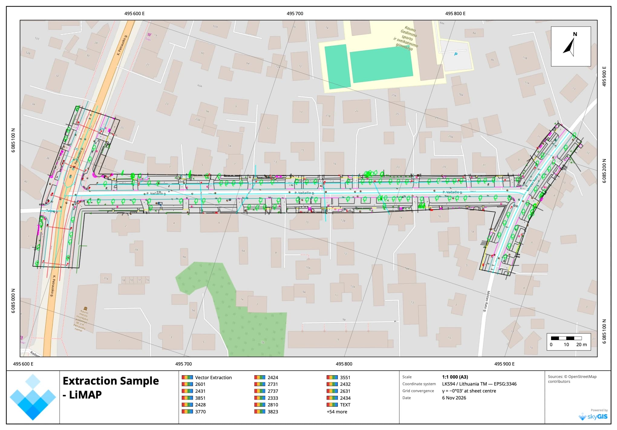
- Paper
- A4, A3, A2 or A1
- Scale
- 1:100 to 1:25 000, or any custom scale
- Output
- GeoPDF, optional JPG + world file
What goes on the sheet
Everything a printed plan needs to be read without the project open.
- Coordinate grid
- Lines, crosses or edge ticks in project coordinates, labelled around the frame, at an automatic or custom interval
- Scale
- Exact at the sheet centre, written in the title block and drawn as a scale bar
- North arrow
- True north, with the grid convergence at the sheet centre
- Legend
- Built from the printed layers; rename or hide any entry
- Title block
- Organisation logo, title, subtitle, project, note, author, date and coordinate system
- Sources
- A credit line for each layer, printed at the bottom of the sheet
Making a map sheet
Open it from the 2D map
Use the Map sheet button on the map toolbar or the Generate menu. The sheet starts centred on the current view, at the finest standard scale that fits it.
Choose paper and scale
A4 to A1, portrait or landscape, at a standard or custom scale. If the site does not run north to south, right-drag the preview to turn the sheet.
Place the sheet
Drag the map under the frame, nudge it with the arrow keys, or centre it on the map view or the data.
Fill in the title block
Click any text on the preview to edit it in place. Rename legend entries and add a credit line for each layer.
Download
Pick 150, 200 or 300 dpi and download the PDF, with a JPG and world file if you need one.
The preview is the PDF
The composer's preview and the PDF are drawn from one layout, so what you see is what prints, down to where each label sits. The scale is exact at the sheet centre, and the grid is drawn through the project's projection, so map and grid always line up.
Every layer the 2D map shows prints too: orthophotos, CAD drawings, vector layers, LandXML and station bands. Orthophotos are fetched again at print resolution, so a 300 dpi sheet carries the detail of the image rather than of your screen. A thinnest-line setting widens hairlines so they survive the printer, and near-white CAD lines print black on white paper.

Georeferenced output
The sheet keeps its place on the ground after it leaves SkyGIS.
GeoPDF
The PDF carries the project's EPSG code and the coordinates of the map frame's corners, so GIS software that reads georeferenced PDFs, such as QGIS, opens it in the right place.
JPG + world file
A georeferenced image of the map frame that you can upload back into SkyGIS as a layer or bring into CAD.
Turned sheets
Turn the map inside the frame for a corridor. The grid, its labels, the north arrow and the georeference all follow the rotation.
What map sheets are for
Good for
- Site plans and location drawings for reports and permits
- Field copies of a survey or extraction at a stated scale
- Plotting CAD over an orthophoto without a desktop GIS
Not built for
- Map books that run over many sheets; the composer makes one sheet at a time
- Vector CAD output; the map prints as a high-resolution image, with grid and text as vectors
- Editing linework on the sheet itself
Questions
How accurate is the scale on a printed map sheet?
The scale is exact at the sheet centre, in project grid metres, and the grid is drawn through the project's projection, so map and grid line up. Print at actual size (100 %) for the stated scale to hold on paper.
Which coordinate systems can a sheet use?
The project's own coordinate system, identified by its EPSG code in the title block. A project on a local grid prints with local coordinates and a local grid north, without a GeoPDF georeference.
Can I open the PDF in GIS software?
Yes. The PDF is a GeoPDF with the EPSG code and the map frame's corner coordinates. You can also save the map as a JPG with a world file.
Why can't I print a Mapbox base map?
Mapbox's licence does not allow its maps in print. Use your own XYZ or WMS base map, OpenStreetMap tiles, an orthophoto or a white background.
Which plan includes map sheets?
SkyGIS Pro. The sheet is made in the browser, with no server job. Shared links are view-only and do not offer it.
See it on one of your own datasets
Pro is priced around your team and data volumes. The quickest way to judge it is a 30-minute walkthrough on a dataset you already have.