True-to-Scale Map Sheets, Straight from the 2D Map
SkyGIS Pro now prints the 2D map as a PDF map sheet at a scale you can measure, with a project-CRS grid, north arrow, legend and title block. No desktop GIS needed.
Why a Map Sheet Still Matters
Point clouds, 3D viewers and shared links have changed how survey data is reviewed. Yet a surprising number of deliverables still end up as a sheet of paper or a PDF: a site plan for the foreman, an appendix to a survey report, a location drawing for a permit application, a field copy for the crew that sets out the next phase.
These sheets come with rules. The scale has to hold when the sheet is printed. The grid has to match the coordinate system the project is set out in. The title block has to say what the drawing shows, who prepared it, when, and in which reference system.
Producing such a sheet usually means exporting layers from one tool, opening a desktop GIS or CAD package, rebuilding the styling and laying out the frame by hand. When the data changes, the work starts again.
The map sheet composer in SkyGIS Pro removes that detour. The sheet is built from the 2D map your team already works in, in the browser.
From the 2D Map to a PDF in One Dialog
Open the composer from the map toolbar or the Generate menu. It starts from what the map shows: the same layers, the same styling, centred on the current view, at the finest standard scale that fits it.
Choose the paper (A4, A3, A2 or A1), portrait or landscape, and a scale. Standard scales run from 1:100 to 1:25 000, and any other scale can be typed in. Drag the map under the frame to place the sheet, nudge it with the arrow keys, or centre it on the map view or on the data.
The preview is the PDF. Both are drawn from one layout, so what you see in the composer is what prints, down to the position of every label.
A Scale You Can Measure
The scale is exact at the sheet centre, in project grid metres. SkyGIS calibrates the print map against the project's coordinate system and then draws the coordinate grid through the real projection, so map and grid are in register by construction. Put a ruler on a printed grid square and it agrees with the scale bar.
The grid is labelled around the frame in project coordinates, as full lines, crosses or edge ticks, at an automatic or custom interval. The scale bar sits in the bottom right of the map frame, and the scale is also written in the title block, where it always stays.
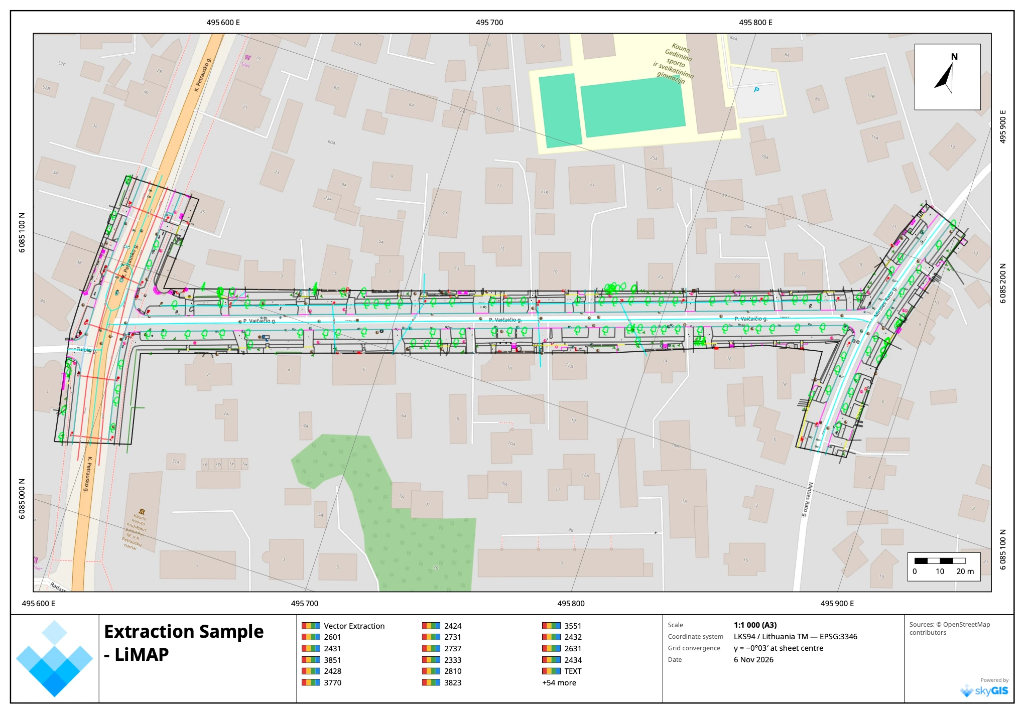
The north arrow points to true north. Because grid north and true north rarely coincide, the title block states the grid convergence at the sheet centre, for example γ = −0°03′ on the sample above.
Turn the Sheet to Fit the Site
Roads, railways and pipelines rarely run north to south. Right-drag or Ctrl+drag the preview to turn the map inside the frame, or type an angle. The grid, its labels and the north arrow turn with it, and the compass in the toolbar puts grid north back up in one click.
Everything the Map Shows, at Print Resolution
Every layer the 2D map draws prints too: orthophotos, CAD drawings, vector layers, LandXML and station bands. Orthophotos are fetched again at print density, so a 300 dpi sheet carries the detail of the image, not of your screen. You can print at 150, 200 or 300 dpi.
CAD linework gets some help on its way to paper. A line weight setting and a thinnest-line limit widen hairlines that would otherwise disappear, and near-white lines, common in drawings made on a dark background, print black on white paper, as they do in the legend.
The background is your choice: your own XYZ or WMS base map, OpenStreetMap tiles with their credit, an orthophoto, or plain white paper. Mapbox base maps are left out, because their licence does not allow print use.
A Title Block That Carries the Facts
The title block holds your organisation's logo, a title and subtitle, a project line, a note, the author and the date. Click any text on the preview to edit it in place.
The legend is built from the printed layers. Rename an entry, hide one you do not need, and if there are more entries than fit, the sheet says how many it left out. Each layer can carry its own credit line, printed in the sources field at the bottom of the sheet.

Georeferenced for GIS and the Field
The PDF is a GeoPDF. It carries the project's EPSG code and the coordinates of the map frame's corners, so GIS software that reads georeferenced PDFs, such as QGIS, opens it in the right place.
If you also need the map as an image, tick the JPG + world file option. You get a georeferenced picture of the map frame that you can upload back into SkyGIS as a layer or bring into your CAD software.
An Example from a Street Survey
The sheet above comes from a street extraction in Kaunas, Lithuania: CAD linework with kerbs, trees, covers and utilities, uploaded to a SkyGIS project.
To hand it over, the extraction was laid on OpenStreetMap tiles, framed on an A3 landscape sheet at 1:1 000 in LKS94 / Lithuania TM, and given a title. The legend filled itself from the CAD layers, and the PDF was ready to attach to the delivery with no export, no restyling and no second program.
Available in SkyGIS Pro
Map sheets are part of SkyGIS Pro and run entirely in the browser, with no server job to wait for. Shared links stay view-only and do not offer the export.
Read more on the map sheet feature page, or see how orthophotos and coordinate systems are set up in a project.